Thursday, November 5, 2026 · Trucking & Freight
Winter Forecast Puts Freight Corridors at Risk Despite Warmer Seasonal Outlook
Noted by Adam Wingfield · 985 reads
A warm winter outlook could mask localized risks from mountain snow, ice, flooding and high winds across key freight corridors.
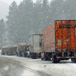
A season that looks warm on average could still disrupt freight across specific lanes and facilities. In a WeatherOptics webinar on the 2026 to 2027 North American winter outlook, head meteorologist Joshua Feldman described a pattern expected to bring repeated storms, mountain snow, ice, flooding and high winds. For shippers and carriers, the practical question is where those impacts will land and how early network teams can act.
That’s a different planning problem from responding to a broad storm warning. The webinar’s speakers argued that weather information becomes more useful when teams can connect a forecast to particular routes, sites and operating decisions. WeatherOptics founder and CEO Scott Pecoriello said the company combines its forecasts with local infrastructure and past impact data to help businesses assess that exposure.
A warm season with concentrated disruption
Feldman attributed the expected pattern to a strong El Niño, the warming of Pacific waters that can influence weather around the world. He put the current weekly sea surface temperature anomaly near 3.4 degrees Celsius. That reading isn’t the three-month average used by NOAA to rank El Niño events, and Feldman’s description of its historical strength went beyond the benchmark commonly cited as the strongest since 1950. Those distinctions matter: the webinar presented the figures and rankings as Feldman’s assessment, not as an independently confirmed record.
In Feldman’s outlook, an active southern jet stream will steer repeated storms and atmospheric rivers from California across the Southwest toward the Gulf. From there, storms may head up the East Coast or move out to sea. He expects below-normal snowfall across most of North America, including much of Canada, with the mountain West a notable exception. Temperatures are forecast to be near normal in the Southwest and Southeast.
Low seasonal snowfall, however, doesn’t rule out severe disruptions. A few storms can close a vital route even if snowfall totals stay below average across a broad region. That’s why the webinar focused on exposure along individual corridors rather than seasonal averages alone.
Mountain routes, ice and flooding
In the West, Feldman highlighted I-80 over Donner Pass in the Sierra Nevada. Repeated atmospheric river storms could bring prolonged mountain snow, closures and chain controls, affecting cross-country movement into the Bay Area. He also expects greater than usual impacts on I-70 through the Colorado Rockies between Denver and Grand Junction, while sudden snow squalls could affect I-40 across the Colorado Plateau near Flagstaff.
On I-5, the principal concern is water and slope failure rather than snow. Feldman pointed to burn scars around Los Angeles and San Diego as areas where heavy rain can raise the risk of debris flows and mudslides. The Grapevine over Tejon Pass could also close during a poorly timed cold snap. When that route is unavailable, a localized closure can force changes to broader West Coast lane plans.
Ice is another major concern, with a risk zone stretching from the southern Plains, including Dallas and Oklahoma City, east through the Tennessee Valley to the central Appalachians. Feldman said one ice storm can shut a corridor for a couple of days. Nashville and Memphis experienced icing that lasted for days last winter, he said, illustrating how a single event can strand freight, idle a facility and disrupt service windows.
Farther southeast, intense local rainfall could close I-10, I-20 or I-95 for a day. Feldman cited a recent two-foot rainfall that shut down I-95 on Florida’s Space Coast. For dispatchers and facility teams, the operational challenge is that rainfall and flooding can vary sharply across a relatively small area.
Wind adds a separate equipment risk
Wind could compound the threats from snow and rain. Feldman said the high Plains, from Texas to Colorado and west into the Great Basin, already experience winds of 70 to 80 miles per hour a few times each winter, and he expects stronger exposure this season. Those conditions can raise rollover risk for high-profile vehicles, particularly when wind hits the same routes as storms.
On the West Coast, Feldman described atmospheric rivers bringing sustained winds of 40 to 50 miles per hour, with gusts approaching 60 in the Sierra. Along the Gulf Coast, a cold front meeting warm, moisture-laden air could trigger damaging thunderstorms, sometimes overnight, when conditions on I-10 and I-20 may be especially hazardous.
The Northeast remains difficult to assess from snowfall averages alone. A cold intrusion timed with a coastal storm could still produce a major blizzard. Feldman pointed to the 2015 to 2016 super El Niño winter: despite its warm profile, Winter Storm Jonas brought about 27.5 inches of snow to Central Park and closer to 30 inches in Washington suburbs, snarling I-95 for days. He also expects frequent nor’easters, with winds above 60 miles per hour on some days, potential closures at choke points such as the Verrazzano Bridge, and coastal flooding affecting Boston and the New Jersey and Delaware shorelines.
Turning forecasts into operating decisions
Pecoriello’s central point was that the same snowfall amount can have different consequences depending on local terrain and infrastructure. An inch of snow in Chicago, he said, isn’t equivalent to an inch in Atlanta. WeatherOptics says its forecasts begin with an in-house model that cuts wind and precipitation forecast error by about 40 percent, then account for terrain and infrastructure. The company also says it draws on roughly 15 years of impact history, including vehicle data, road closures and damage reports, to produce risk scores at a resolution of about three kilometers.
The company’s approach is intended to let different teams assess one weather event against their own operating needs. Transportation teams can check which shipments may run late and consider holding or rerouting traffic. Safety teams can monitor wind conditions that threaten trailers. Supply chain teams can assess wider network disruption, while facilities teams can track risks to distribution centers and stores, including potential power loss. Continuity and HR teams can consider exposure for staff working at affected sites.
Pecoriello said the forecasts can be delivered through systems teams already use, including transportation management systems and electronic logging devices, as well as executive briefings. The company describes a forecast horizon of about seven days, with more actionable detail in the three-to-five-day window when companies may decide to hold shipments, reroute them or stand down operations. Alternate routes may add miles while reducing exposure to weather risk.
For freight operations, the useful takeaway is to map forecast impacts to lanes, facilities, shipments and people before conditions deteriorate. The outlook and platform figures in the webinar reflect WeatherOptics’ own forecast and claims, as presented by Feldman and Pecoriello; they aren’t independent verification. The webinar was hosted by WeatherOptics, a FreightWaves SONAR data partner. The source material includes further coverage of how ice can halt freight, WeatherOptics weather data and winter weather risks for fleets.
Source article appeared first on FreightWaves.